Biri Island is one of the most enthralling towns of
Northern Samar, a true natural gem of the Philippine archipelago. It is known
for its breathtaking rock formations engineered through time by big waves of
the San Bernardino Strait that get a kick out of the eastern portion of its
shoreline. It is situated at the northwestern tip of Northern Samar.
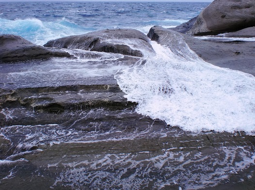
This peace-loving island is where Magasang Rock
Formation could be enjoyably viewed, an amazing natural
wonder composed of seven gigantic limestone rocks within four small and rocky
islands. Its rocky panorama, actually one of the country’s most amazing
geological beauties, bequeaths vast potential for adventure. The rock formation
has been described as the place of the “battle of the gods” where pounding of
strong winds, the movement from tectonic plates, frequent storms, the heat wave
and huge death-defying waves smashing the rocks engineered this superb
exquisiteness. The mighty of these natural forces brought the islands to take
on only of its kind and remarkable shapes. Sightseer can enjoy dipping on tide
pools fashioned by the sea and layers upon layers of sandstone beds gradually
deposited into the sea overtime which have been exposed to the uplift of the
rock formations. Geologists deem that the rocks date back from Early Miocene Period and their ages range from 5 to 23 million
years old.
 |
| A place of the battle of gods where pounding of strong winds conquer your fears! |
From a distance another rock formation called Bel-at can be explored. These two gigantic, marvelously nature-engineered rocks are about the size of a three-story building, erect disjointedly on a wide flat rock. A big rock formation holding a bat cave underneath can be sited in Bel-at.
 |
| Enjoy dipping on tide pools sculpted by nature itself! |
These attention-grabbing spots have been creating a center of attraction for both foreign and domestic tourists. It became so popular when one of the scenes of the romantic movie entitled "IIsa Pa Lamang" starred by Richard omez , Dawn Zulueta and Maricel Laxa hMaricel Laxa was filmed. It also captured Film Director .Chito Roños heart to be the setting of his adventure-horror drama film called "Spirit Warriors II" starred by Danilo Barrios, Vhong Navarro and Chris Cruz. Likewise, these spots were featured in the 2001 Calendar poster of the Philippine National Oil Company (PNOC) as one of the Geological Wonders of the Philippines.
 |
| Simply irresistible! |
In terms of financial resources, the island town is considered as fifth class municipality. Its average annual income from 1996-1999 reached up to Php 7.6 million. The Internal Revenue Allotment (IRA) of the municipality amounted to Php 16.1 million in 2006. This translates to an IRA per capita of Php 1,493, the sixth biggest among the municipalities.
 |
| Wanna ride a boat, without encountering a congested traffic, for a change! |
Concerning its education sector, the municipality has a total of 11 government elementary schools and 2 government secondary schools. In School Yea 2006-2007, both teacher to pupil/student ratio in elementary and secondary schools stood at 1:38.
 |
| As the boat docks at the port of Biri island! |
Expect hundreds of sites and thousands of routes hanging
around in this island for the fearless climber.
The island town has been much-loved for photography aficionados
and excursionists, particularly on summer when the weather is quiet. Visitors
spend the day taking pleasure on the site and enjoying a dip in the cool turquoise
blue water. Likewise, it is fascinating to surfers during the months of October
to January, with its wonderful rising and falling waves.
 |
| Serenity that everyone yearns, beyond the torrents from a distance! |
Formerly, Biri was an island barangay under the
jurisdiction of Bobon, Northern Samar until it was converted into a new and
independent municipality under Republic Act No. 5500 on June 21, 1969. It
became the 21st municipality of Northern Samar.
The island was accustomed to be Tingiao, as referred
to in the Spanish Galleon navigational maps and was the entry point to Luzon
and Visayas.
 |
| Approaching Lavezares from Biri Island, which is approximately an hour travel! |
As navigational landmark, the name “Biri” was drawn
from the Spanish word “barrer”, which means to sweep. Consistently when the Spanish captain of the Galleon would catch
sight of the San Bernardino Isle and Biri of Tingiao, the captain would charge
his men “barrer” or clean the galleon deck in preparation of their disembarking
to the Capul Island for their voyage to Manila. Sporadically, the Spanish Galleon
would anchor at Biri Bay prior to their navigation to Manila.
 |
| How could you resist such magnificence! |
Whereas in the Island, inhabitants would hear the
Spaniards naming the Island “verey.” Subsequently, the word “verey” had been
prevalently known as “Biri”. Other accounts would claim that its name in the
course of time developed simply as “Biri” depending on the person’s auditory
efficacy.
 |
| Nature engineered, indeed! Spectacular! |
During World War II, Biri was the site of the
Japanese Garrison Signal Corps brought by its strategic location from the
Pacific Ocean. Many Biri-anons turned to be the onlookers to the passing of the
American submarine and other warships during
Leyte’s independence.
A bomb-made lagoon still exists inside the Biri
Central Elementary School, which is my alma mater.
 |
| On spare time, my brother Marvin caught this beautiful blue starfish which can be viewed basically underneath! |
Geographically Biri is located in the northernmost
tip of Northern Samar, facing the Pacific Ocean to the East and the famous San
Bernardino Strait to the west.
It has a total land area of 24.6 square kilometers
which is composed of 8 barangays namely, Pio del Pilar (also called as Macaret),
MacArthur (also Called as Tampipi, Kauswagan (also called as Basud), Progress
(also called as Talisay), San Antonio, San Pedro and Santo Niño (also called as
Palhugan).
The island registered a total population of 10,987
in the 2010 Census of Population whose population density of 433 persons per
square kilometer is the third highest among the 24 municipalities of Northern
Samar.
 |
| A relaxing mood as my sister Christine enjoys her get away! |
Biri inhabitants are a mixture of Waray and Bicolano
culture. The inner occupiers speak Waray dialect while the outer island inhabitants
speak Bicol-Waray vernacular.
With regards to socio-economic endeavors, the
natural resources of the municipality consist chiefly of fish and other marine
products. Fishing evidently is the primary sour in the of revenue of the
community. During the months of March to September, the Biri-anons are engaged in
catching fish and squids like kulambutan, tabugok, tustos, muko-buko, kugita, tagbulakaw,
tamala, and many more. The common people
are also into rice, root crop and coconut farming.
Through the Kaway Festival, Biri nurtures a culture
of peace in harmony with nature, and hopefully be the access to the arts and
culture of Northern Samar.
The captivating Biri Island can be reached in 14
hours by bus or private vehicle from Manila or roughly an hour and fifteen
minutes flight from Manila to Catarman, the capital town of Northern Samar. The
island can finally be reached in 30 minutes by sea from the town of Lavezares via
motorboats.
Motorboats are used for inter-island transport while
motorcycles are available in the town proper.
 |
| Island of Biri is facing Mount Bulosan of Bicol Region |
GETTING TO BIRI: The nearest airport to Biri
Island is Catarman, served by Air Philippines , Cebu Air , Zest Air, and Philippine Airlines.
From Catarman, take a jeepney going to Lavezares
Port, about a 30-minute trip. Then take a boat to Biri Port, which may take
approximately an hour.
Source:
- National Statistical Coordination Board, Regional Division VIII, Eastern Visaya, Biri: an island with magnificent rock formations, http://www.nscb.gov.ph/ru8/Profiles/Municipal_Profile/Municipal_Profile_Biri_Island_Northern_Samar.pdf
- http://opaep.com.ph/discovering-biri-island/, Discovering Biri Island


2 comments:
wow.. it's only now that i've know about this place.
thank you... for posting this..
ang ganda.. ang ganda talaga... ang ganda-ganda...
You have to experience it by yourself Annievnc for a guaranteed enjoyment that's away from traffic congestion and air pollution. Thanks for dropping by. Best regards!
Post a Comment